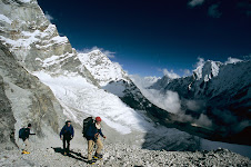
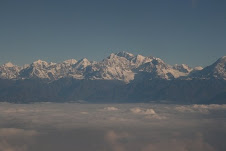
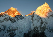
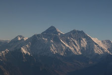
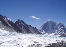
Everest Expedition (8848 m)
Even though Sir E. Hillary & Tenzing Norgay has conquered the highest mountain in the world many times ever since its first conquest in 1953. Everest is still as mysterious, beguiling and magnificent as ever. Standing incredibly tall silhouetted against the shared sky of Nepal and Tibet , this mountain has many names Chomolungma, Sagarmatha, Qomolungma or Mt. Everest . Whichever name one chooses, its mystery still lives on...
Perhaps the most colorful story about the early attempts on Everest is the one involving Captain J. Noel and his native companions. He disguised himself as a Mohammaden and made a journey from Darjeeling through Northwest Sikkim and round the north of Kanchenjunga in an attempt to reach Everest. Unfortunately, he had to retreat back short of just sixty-five kms from Everest when a posse of Tibetan soldiers forced them to turn back.
Kanchanjunga Expedition (8586m)
Mt Kanchajunga (8,586m / 28,170ft) Located on the Sikkim ( India )- Nepal border as part of the Himalayan mountain range at longitude 27º42' North and 88º08' East, Kangchanjunga 8,586m / 28.170ft.) is the third highest mountain in the world.
The other name of Kangchenjunga is Kangche Dzo-nga, Kachedzonga, and Kangchanfanga means "The Five Treasures of the Snow" in the local dialect referring its five summits all over 8000 meters. Kangchenjunga has 5 peaks, of which the true Summit is 8,586 meters /28,169 feet.
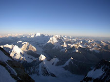
Dhaulagiri Expedition (8167m.)
The Dhaulagiri Himal lies south of the Tibet/Nepal border and the culminating high point at its eastern end is Dhaulagiri l, the seventh highest mountain in the world, which towers in solitary splendor. This magnificent peak rises as a giant shoulder of shining ice and snow. It got its name from the Sanskrit word "Dhavala" which means 'white' and ‘giri', which means mountain.
This mountain was first sighted by the British surveyors in India in the early 1800s but remained virtually unknown until a Swiss aerial survey in 1949. This White Mountain was first climbed in 1960 by the Swiss following the Northeast ridge. Five ridges buttress Dhaulagiri one and even up until the early 1980's only the Northeast ridge had been successfully climbed. Dhaulagiri is considered the most interesting peak among the eight thousands Mountains.
Manaslu Expedition (8463m)
Mt. Manaslu (8,163m / 26,781ft) Located 28.32.58 longitude and 83.33.43 latitude Manaslu is situated in the central region of Nepal in the Gorkha massif is the eighth highest mountain in the world. The name Manaslu was derived from the Sanskrit word "Maanas" meaning "soul" or "intellect". Japanese were the first to climb Manslu Mountain in 1956, therefore it is still considered as Japanese peak by many people. Though there are many routes to Manslu mountaineering , as the long ridge Manaslu base camp and valley glacier offer feasibility to approach from different directions, but South Face is considered to be the most difficult.
Annapurna Expedition (8091m)
Annapurna is also known as the store of the rise, located in Himalayan ranges of Nepal . The best climbing seasons is on April, May (pre-monsoon) and late September, October (post monsoon). Gokyo Treks & expedition has catered the needs of mountaineers climbing Annapurna Expedition/Mountaineering in a professional and committed manner. Annapurna 8091m was first climbed by a French expedition in 1950. There are four summits called Annapurna, the entire massif forms a barrier on the northern side of the pokhara Valley . The main summit of the Annapurna sanctuary/Annapurna base camp , Annapurna II is above Chame, about 24km to the east. Fewer climbers have reached the summit of Annapurna than any other 8000m peak in Nepal .
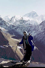
Ama Dablam Expedition (6812m)
Ama Dablam has long been considered the prettiest mountain in the world. High on her Southwest face hangs a glacier resembling a 'Dablam' - the sacred ornament box worn by the ladies in Sherpa community. It was this spectacular feature that got her the name "Ama Dablam". She lies alongside Everest in the heart of the Khumbu valley offering a superb climb up a spectacular ridge.
The route we follow begins at Lukla (2850m) and the initial days of the trek pass through the legendary Sherpa country up the spectacular high valley of the Khumbu. Much of the route on the actual climbing is fixed with no icefall or glacier to negotiate, and most of it is concentrated on the crest of a ridge. The climb is relatively safe though exposed and steep and not really a mountain for debutantes.
Pumori Expedition (8463m)
Pumori Ascend – More information
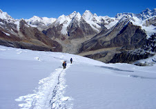
The ascent starts at 5,300m. In a beautiful base camp aside a small lake (water source, take water filters or barrels - where you can pack your equipment- and to clarificate the water -let sand to drop all night-). From base camp you have the most wonderful sight of Mt. Everest you can imagine, just above is Kalapattar Rock hill at 5545m.
After a 3 hrs walk (loaded) trough an easy hike terrain you will reach camp 1 or advanced base camp 5700m. To let your equipment and supply nearby. After this you will face a 500m. Elevation difference trough a 40 to 65 degrees slopes, 100m. Horizontal traverse, steep and expose to wind narrow ridges, some 5m. Ice wall, one tunnel climb. Pumori has many rock and mixed climb (not to need rock pitons but take some in case for the fixed rope) and spring might be more rock falling. If you have good Sherpa, Could be good for spring season.
Camp 2- 6200m. Is located on a narrow ridge at the end of the section described before. Expose to wind and far from avalanches (but people say it has happened before that avalanches reach camp 2) the next 400m. Is an ice climb with 35-65 degrees, more 5m. Ice walls, many crevasses, and the bigger avalanche danger from big seracs hanging from the shoulder 6500m.
The shoulder can be camp 3, but is too windy and not much gain. From here you cans see Tibet. After this it is presume that the rest is a wide ridge that takes you to a not hidden summit, but like I told you, You still need rope here because of many crevasses, Ice walls.
Finally, at 6,850m, there is an enormous crevasse 200m large, 40m. Deep, 10-20m wide. Try to walk towards Tibet side where the crevasses ended just before a great cliff, but in the other side the snow two-layer difference for avalanche danger. You can try Nepal side and you can reach the beautiful famous Pumori cliff and crossed the crevasse. After this the walk to the summit is only walk & you can summit Pumori 7145m.
Normal route: This is the easiest route to climb this peak and most of the expedition climbed this peak so far have used this route. As you know Pumori is not easy as like other mountains, there are technical parts in this route as well. We suggest you, you have take climbing Sherpa and who will take to Summit. We can arrange for you summiter Sherpas for the Pumori, if you have required.
You need to have at least 3 camps after base camp to reach the summit. The base camp is just above Gorekshep at the altitude of 5300m. After base camp, you can set up first camp at the altitude of 5,650m. Around the phase of Pumori.
We set second camp at the ridge after the phase at the altitude of 6,000m. The most technical part for this peak is around camp 1 and 2. We set camp third at the altitude of 6,480m. Around the corner after the ridge. you can summit from the third camp to the top. This route has been used by former expedition to Pumori in every year.
South-West ridge: Only few climbers tried this route, as this is one of the most difficult routes. This route follows directly from the top of Kalapatar and goes straight over the ridge nearly 75 Degree. As this route has lots of technical difficulties, I recommend you to use the normal route for the Pumori and you & your group will reach the Top.
I will update more information soon........
Subscribe to:
Post Comments (Atom)


.jpg)
.jpg)


.jpg)
.jpg)

+-+Pokhara.jpg)
.jpg)
.jpg)
2 comments:
I would like to be there once............
That's amazing view. A perfect place for trekking.
Post a Comment